National Broadband Ireland (NBI) is contracted by the Department for the Environment, Climate and Communications (DECC) to roll out state-of-the-art fibre infrastructure across Ireland, as part of the State’s National Broadband Plan; ultimately delivering high-speed broadband to every rural home and business in the intervention area.
This high-speed fibre and future-proofed broadband network covers 1.1 million people living and working in over 564,000 premises, including 91,000 businesses and farms, along with some 672 schools. Equal internet access will enable equal opportunities for everyone, no matter where they live, work or study. This is the largest telecommunications project ever undertaken by the Government of Ireland, and the largest of its kind in Europe.
For this project, Ireland is divided into 227 Deployment Areas (DAs), including all our offshore islands. As part of the deployment phase of the project, each DA has Survey, Design, Build and Connection Phases. Spatial data underpins the rollout and requires systems and processes that can integrate with each other and have the ability for data translation. FME is central to the integration of data across NBI systems in the project deployment phase.
“FME is crucial to NBI’s geospatial processes, validation, and data management, enabling scalable processes essential for the deployment of the NBI Network. As the number of designed and built Deployment Areas increases, the ability to process and track large volumes of data simultaneously becomes increasingly important. FME’s interoperability capabilities ensure the seamless movement and management of data across various stages of the project”, Brian O’Malley, GIS Manager, National Broadband Ireland.

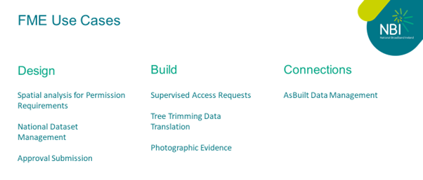
NBI leverages FME to streamline and automate data processing across various stages of their infrastructure projects, from design to build and final supporting evidence for milestone payments. The integration of national datasets and automated Quality Control (QC) processes enhances efficiency and accuracy, ensuring seamless project execution and compliance with regulatory requirements.
A sample of FME use cases is detailed below.

National datasets (OSI mapping, existing utility data, CSO datasets) need to be viewed by NBI staff members and onsite teams alongside NBI network data in ArcGIS Online. National datasets are received by NBI in a range of formats. It is important that datasets can be accurately updated with minimal downtime.
This is a snippet of a workbench translating utility network data received from an external source in CAD format to NBI’s ArcGIS Enterprise geodatabase.

The benefits from using FME in this scenario include:

For NBI to perform core drilling in existing third-party chambers, a supervised access request must be submitted weekly, including photos and x/y coordinates of the chamber. The approval or rejection of these requests is based on the provided information.
This process ensures that all core drilling activities are accurately documented and meet the data requirements, facilitating smooth and compliant operations.
Deployment Areas are divided into smaller sections called ribbons. AsBuilt designs are provided to NBI by our design partners in shapefile format on a ribbon-by-ribbon basis. FME is used to extract only the relevant ribbon data from the design packs, allowing AsBuilt maps to reflect the latest infrastructure changes in each DA. This enhances the accuracy and reliability of NBI’s mapping and inventory management.

In summary, these processes underscore FME’s pivotal role in ensuring efficient, accurate, and scalable data management and integration, critical to the successful execution of NBI’s broadband rollout.
National Broadband Ireland
Telecoms